 |
 |
Jewish
History
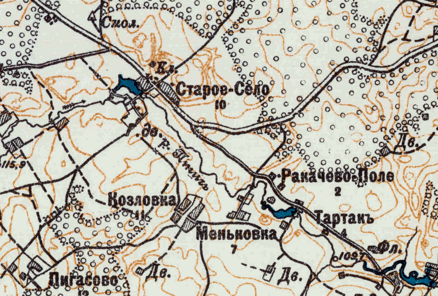
By 1873, Staroe Selo had a public primary school, but the closest railway and telegraph stations were in Ratomka (6 miles northeast) and the closest doctor, post office and synagogue were in Zaslav (8 miles north). By 1890, there were five inns, two mills, a sawmill, and a brewery.
Rakachevo field (Ракачево Поле), located about 2 kilometers southeast of Staroe Selo along the Ptych river, included an apple orchard and apiary in the early 1900s.
| Time Period | Region |
| Before 1793 | Polish-Lithuanian Commonwealth |
| 1793 - 1918 | Russian Empire |
| 1918 - 1919 | Belarusian People's Republic |
| 1919 - 1991 | Soviet Union |
| 1991 - Present | Republic of Belarus |
| Year | Jewish Population | Total Population |
| 1905 | 226 | |
| 1917 | 20 | 256 |
| Geographical
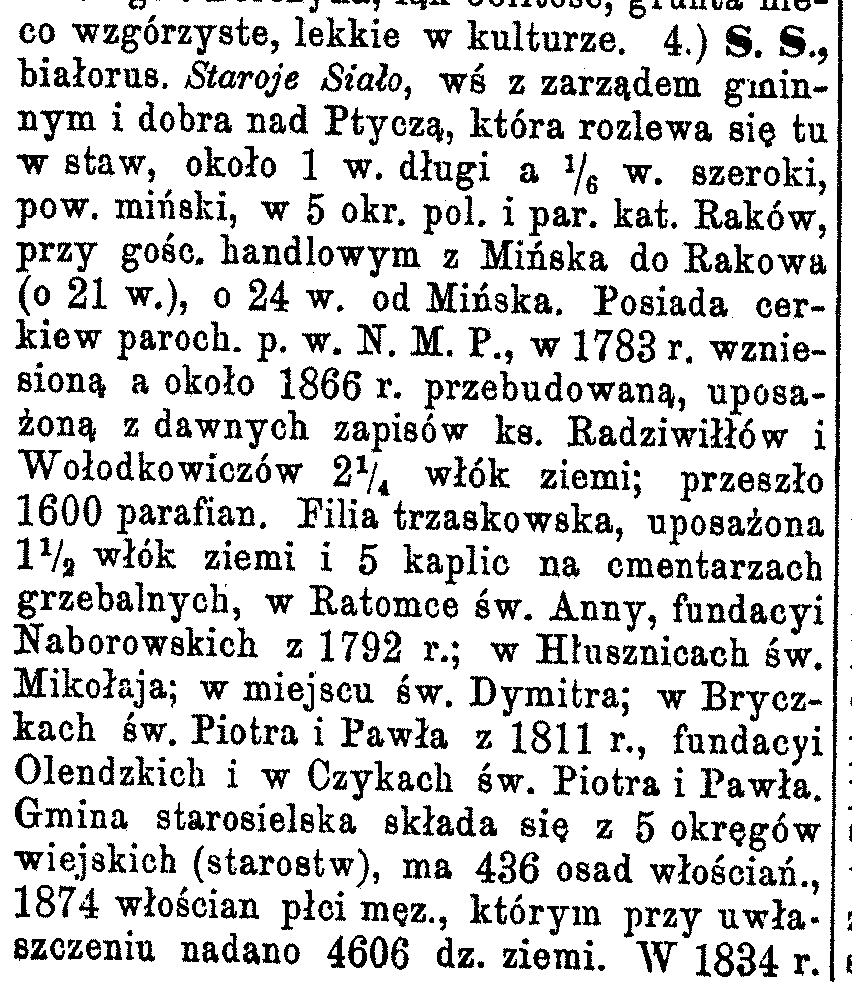
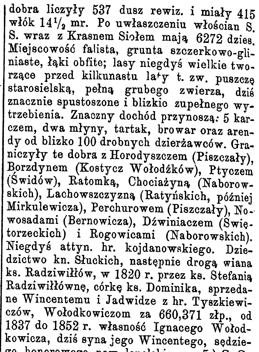
Dictionary of the Kingdom of Poland and Other Slavic Countries (Słownik Geograficzny Królestwa Polskiego i Innych Krajów Słowiańskich) Warszawa, 1880-1902 [Vol. XI, page 242, entry 4 of Stare Sioło] |
|
 |
 |
| Stare Sioło, białorus. Staroje Siało, wieś
z
zarządem gminnym i dobra nad Ptyczą, która rozlewa się tu w staw, około
1 werst długi a 1/6 werst szeroki, pow. miński, w 5 okręge pol. i
parafia katolik Raków, przy gościnny handlowym z Mińska do Rakowa (o 21
verst), o 24 werst od Mińska. Posiada cerkiew paroch. pod wezwaniem N. M. P., w 1783 r. wzniesioną a około 1866 rok przebudowaną, uposażoną z dawnych zapisów ks. Radziwiłłów i Wołodkowiczów 2 1/4 włók ziemi; przeszło 1600 parafian. Filia trzaskowska, uposażona 1 1/2 włók ziemi i 5 kaplic na cmentarzach grzebalnych, w Ratomce W 1834 dobra liczyły 537 dusz rewizja i miały 415 włók 14 1/2 mr. od 1837 do 1852 rok własność Ignacego Wołodkowicza, dziś syna jego Wincentego, sędziego honorowego powiat lepelskiego. Stare Sioło, Belarus. Staroje Siało, a village with commune management and an estate on the Ptych [river], which spreads here into a pond, about 1 verst long and 1/6 verst wide, in Minsk district, in the 5th Polish precinct and Catholic parish of Raków, along the trade route from Minsk to Raków (about 21 verst), about 24 verst from Minsk. Has a parochial church. dedicated N. M. P., in 1783 erected and around 1866 rebuilt, endowed with the old records of priest. Radziwiłł and Wołodkowicz 2 1/4 earth fibers; over 1600 parishioners. Saskowska branch, equipped with 1 1/2 tens of soil and 5 chapels in burial cemeteries, in Ratomka In 1834, the estate had 537 people in the revision list and had 415 włók 14 1/2 morgens. from 1837 to 1852, the property of Ignacy Wołodkowicz, today the son of his Wincenty, honorary judge, Lepelski poviat. [1 verst is approx. 1 km; 1 włók is approx. 50 acres] |
|
|
|
|||||||||
 |
|||||||||
| Название местечек, сел,
деревень и проч. населенных пунктов Name of towns, villages, villages and other settlements |
Какого уезда, волости, о стана What county, parish, or precinct |
Название
ближайшей жел.-дор. станцие и разстояние до нея верст. от васеленнаго
пункта The name of the nearest railway. station and distance to it from populated area |
Название ближайшей почт.
учреждения (адрес для имсем) и разстояние до него в верстах от
населенных пункта The name of the nearest postal institutions (address for them) and distance to it in versts from settlement |
Название ближайшей
почт.-телогр. учреждения (адрес для имсем) и разстояние до него в
верстах от населенных пункта The name of the nearest postal institutions (address for them) and distance to it in versts from settlement |
Число жителей обоего пола. The number of inhabitants of both sexes. |
Разстояние в верст. от насел.
пункта до: Distance in verst from settlement to: |
число дворов в населенный пункт Number of households in the settlement |
||
| губ. гор. Province city |
уездн. г. District city |
вол. правл. [правление] County government |
|||||||
| Поле Рокачево, дер. | Мн., Старосельской, 3. | Ратомка, ЛРжд. [Либаво-Роменская железная дорога] 12. | Старосельск. вол. правл. 2. | Ратомка 12. | 63 | 20 | 20 | 2 | 3 |
|
Minsk Gubernia
Gazette
(Список населенных мест Б.С.С.Р. (б. Минской губернии)) 1924 [НИАБ 136/13/171а, Film 2044163] |
|||||||||||||||||
 |
|||||||||||||||||
| Distance in verst to: | Houses | Residents | |||||||||||||||
| County | District | City | Males | Females | Both | Belarusi | |||||||||||
| 205 | Поле-Рокачево | хут. | 2 | 18 | 18 | Ратомка | 10 | 2 | [1]0 | 8 | 18 | 18 | - | - | - | - | - |
Research Notes
1. Although the above
Russian military map
was published in 1916, the information appears to be from a 1908 survey
("Печатано в Х-1916. По съемкам 1908 г. чермили в 1915 году горизонтали
чертежи."). The number of houses in each locality is provided
below the name (e.g, Staroje Siało has 10 houses and Rakachevo Pole has
2).
2. A primary source for the history is "Staroye Syelo before 1917" by Oleg Perzashkevich and Alexander Remenchik
2. A primary source for the history is "Staroye Syelo before 1917" by Oleg Perzashkevich and Alexander Remenchik